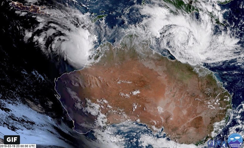
A state of emergency has been declared by Northern Territory’s chief minister Michael Gunner as Cyclone Trevor barrels towards the east coast of the Northern Territory after leaving a trail of destruction behind in north Queensland.
NT Chief Minister Michael Gunner on Tropical Cyclone Trevor: 'It is really important that you stay informed and listen to all of the updates and take this seriously, not just the cyclonic event but the storm surge that comes with it.' MORE: https://bit.ly/2Tkqko3 #SkyLiveNow
由 Sky News Australia 发布于 2019年3月20日周三
The now category one storm is offshore over the eastern Gulf of Carpentaria where it is due to rapidly reintensify on March 21, into a category three storm as it slowly crosses the gulf.
But it’s then expected to further intensify and could emerge as dangerous category four cyclone when it crosses the Northern Territory coast on Saturday, the Bureau of Meteorology said on Thursday, March 21.
Tropical Cyclone Trevor has moved offshore over the eastern Gulf of Carpentaria. #CycloneTrevor https://t.co/AWJKLhynnl pic.twitter.com/O7uGcdegEW
— Bureau of Meteorology, Northern Territory (@BOM_NT) March 20, 2019
“Very destructive winds, with gusts to 260 km/h, heavy rainfall and a very dangerous storm tide are expected near the cyclone centre as it approaches and crosses the coast,” the bureau added.
The bureau is predicting that the cyclone will make landfall later this week between Borroloola and Groote Eylandt as a category four severe tropical cyclone, with marine conditions in the Gulf of Carpentaria deteriorating from Thursday.
The Southern Hemisphere is particularly busy, as seen here by #Himawari8. Tropical Cyclone #Trevor continues to track toward the Gulf of Carpentaria while newly-formed Tropical Cyclone #Veronica takes aim at Western Australia. More: https://t.co/EfW5Fa4JQ7 pic.twitter.com/iXMhOUFfdZ
— NOAA Satellites (@NOAASatellites) March 20, 2019
Residents in the east of the Northern Territory are being evacuated in what is the largest mass evacuation since cyclone Tracy in 1974. The entire community of Groote Eylandt with a population of about 2,800 people is being evacuated by air.
— Jane Bardon (@JaneBardon1) March 21, 2019
The smaller community of Numbulwar with more than 500 residents is being evacuated by road as they will likely be cut off otherwise.
“Our information tells us that this severe cyclone will be extremely dangerous and too dangerous for people to shelter,” Northern Territory Emergency Services regional controller Travis Wurst said.
“The system will be large and intense, with significant damage expected.
“Some people have already self-evacuated.
“Everyone else in these communities is asked to be ready for evacuation across today and tomorrow.”
Local authorities were working to ensure all people were aware of the dangers present and the need to evacuate, he said.
A Tropical Cyclone Watch has been issued for Nhulunbuy to the Queensland border.
Storm Tide is expected on the west coast of Cape York Peninsula between Mapoon and Aurukun on this afternoon's high tide. Large waves may produce minor flooding along the foreshore. #Weipa. Our #CycloneTrevor warnings can be found at https://t.co/FQMfW6tabd pic.twitter.com/93FoHU1ugF
— Bureau of Meteorology, Queensland (@BOM_Qld) March 21, 2019
Other East Arnhem communities are being warned to prepare for destructive winds, heavy rainfall, and very dangerous storm tides as the tropical cyclone intensity could last for more than 24 hours before it weakens as it moves inland.
Katherine is being considered for evacuees as a reception, registration, and transit point with further accommodation arrangements being explored.
The system is likely to increase to a category four system by Friday with very destructive winds making landfall in the eastern Arnhem or Carpentaria district in the Northern Territory.
In Queensland, Trevor has uprooted trees, caused flooding and roof damage, closed schools and roads, and downed power lines with severe wind gusts and heavy rain since it made landfall in earlier this week.
Trevor lashed the Aurukun community overnight and some 180 places were without power on Thursday as residents began cleaning up.
Cyclone Trevor has intensified too a major Category 3 Hurricane, and it has made landfall in Queensland Australia. Although it does not mean that the storm has reached its peak intensity…yet. Dangerous wind, storm surge, and life-threatening flooding is ongoing for 24 hours. pic.twitter.com/JEEP10A6nG
— Nicholas Barretto (@Nichola56831129) March 19, 2019
Local Emergency Management Committees had met and started local plan activations affected communities.
Weather permitting, crews would fly in from Mareeba and Cairns to begin the restoration effort, Ergon Energy said.
The timing is uncertain with gales still expected across western parts of Cape York Peninsula on Thursday morning between Cape York and Pormpuraaw.
That will include Aurukun and Weipa as the cyclone moves offshore and re-intensifies with possible gusts in excess of 130 kilometres per hour.
A heavy rain and a storm tide is also likely between Mapoon and Aurukun on Thursday morning.
Crews restored power to the community of Coen on Wednesday night and have begun resupplying Lockhart River, where the electricity network damage was worse.
“We are down to 96 customers without power in Lockhart River from a peak of 150 customers, or the entire community,” Ergon says.
People have been warned to beware of flash flooding.
With reporting by NTD staff

