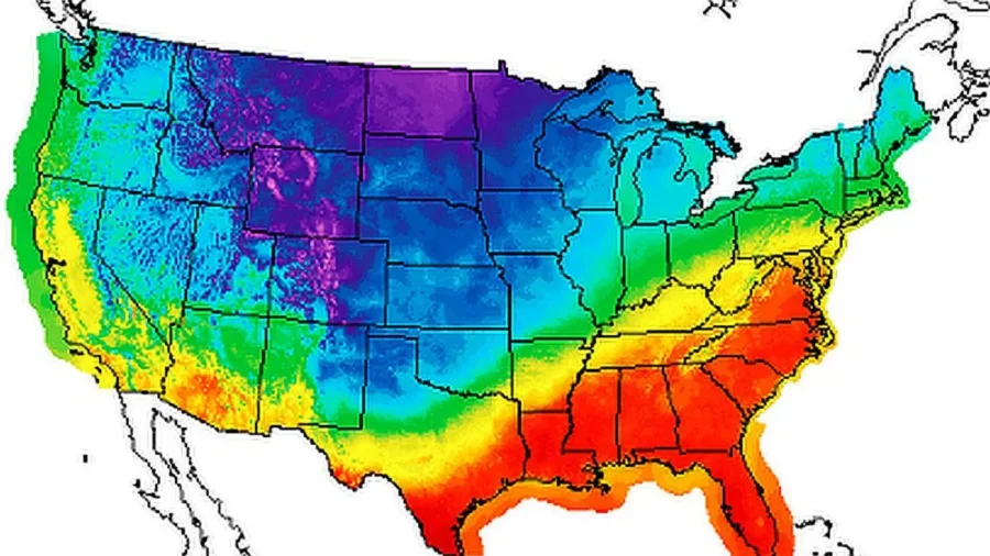
Fresh off the heels of the first winter storm to hit the United States this week, weather forecasters are predicting a blast of arctic cold air that will spread across the United States and Canada over the next week or so.
The National Weather Service (NWS) on Thursday said that for the upcoming weekend, “bitterly cold, winter-like air will continue for the Northern Rockies/Plains behind a strong cold front even as the winter storm tapers off.” Montana, Wyoming, and the Dakotas are currently seeing heavy snowfall in some areas, it said.
According to the weather website Severe Weather Europe, the cold temperatures is part of “an early polar vortex event that will produce strong cold weather pattern change across Canada and the U.S.”
“The polar vortex is currently normal in size and has a growing cold core over the polar regions,” the site said,” adding that it “looks like a ‘cyclone’ with a cold core near its low-pressure center.”
Notably, cold air from Siberia, Alaska, Greenland, and northern Canada will move down across the United States, Fox Weather predicted on Thursday, describing it as an “arctic air mass” or an “arctic blast” that will impact the Halloween holiday. For example, Chicago will see a 20-degree drop between Friday and Saturday, while cities in Minnesota and Wisconsin will also see temperatures plummet.
“Eventually, we do get enough cold coming in from the Russian source, from the Canadian source, that we start to see our temperatures near the freezing point right around the Great Lakes,” Fox Weather meteorologist Amy Freeze said via the website.
It is also possible that areas around the Great Lakes could see snow over the weekend, including Cleveland, Ohio; Erie, Pennsylvania; and portions of western New York state, according to the Fox forecast.
Also on Thursday, AccuWeather forecast that “very cold air will move “southward from Canada from late this week into early next week,” and that “temperatures are forecast to be anywhere between 10 and 20 degrees below the historical averages for late October.”
The website added: “The fall chill is expected to settle in across the entirety of the Midwest by early next week. Temperatures are also expected to fall well below historical averages across the Plains. Children in places like Chicago, Minneapolis and even Oklahoma City may want to consider wearing extra layers underneath their costumes to stay warm.”
❄️ Snow continues across much of the mountainous Northwest into the High Plains as temperatures fall. The storm will continue to move eastward with additional snowfall continuing on Thursday. See our latest Key Messages for more information. pic.twitter.com/IOYnVscA71
— NWS Weather Prediction Center (@NWSWPC) October 25, 2023
Areas across Montana, North Dakota, South Dakota, Idaho, and Wyoming have already seen temperatures drop well below freezing in recent days. Up to 13 inches of snow, for example, fell on Helena, Montana, and upwards of six inches fell in Washington’s Cascades, northwestern North Dakota, and northeastern Montana this week.
Winter storm warnings are in effect for portions of Montana, Wyoming, North Dakota, and South Dakota as of Thursday afternoon, according to the NWS.
The storm warnings were issued this week after the National Oceanic and Atmospheric Administration (NOAA) recently released its winter outlook that predicted warmer temperatures in the northern United States and wetter conditions in the south.
“This year, El Niño is in place heading into winter for the first time in four years, driving the outlook for warmer-than-average temperatures for the northern tier of the continental United States,” the NOAA said.
Between December and February, “wetter-than-average conditions” are forecast for northern Alaska, some western states, southern Plains states, the Southeast, Gulf states, and the lower mid-Atlantic states, according to NOAA’s forecast.
At the same time, it predicted “drier-than-average conditions across the northern tier of the U.S., especially in the northern Rockies and High Plains and near the Great Lakes.”
In contrast, the Old Farmer’s Almanac forecast that “snowfall will be above normal across most snow-prone areas” other than the Pacific Northwest. Temperatures across the United States will see “normal to colder-than-normal temperatures in areas that typically receive snow,” and only New England and the Atlantic Corridor will enjoy winter temperatures milder than typical for their regions.”
From The Epoch Times

