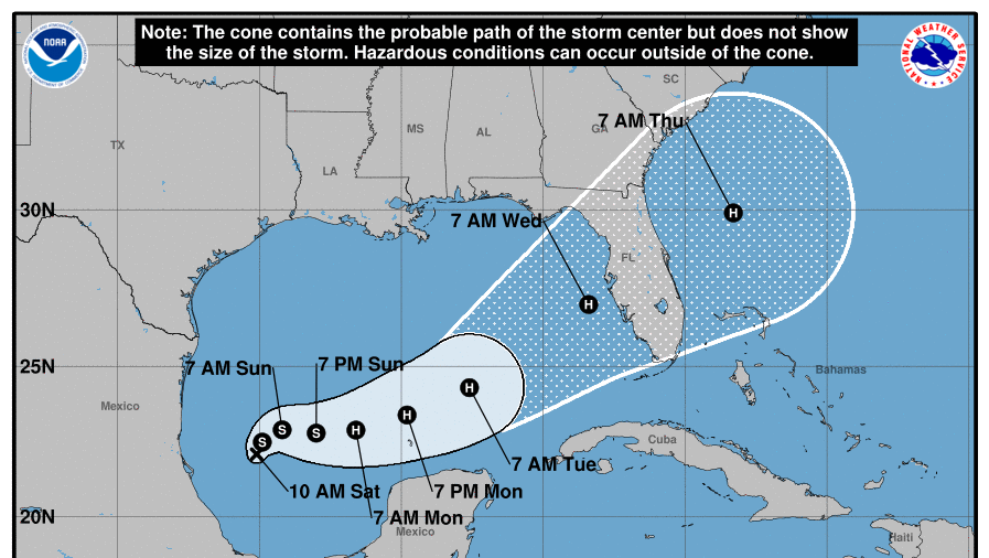
TAMPA—Tropical Storm Milton formed in the Gulf of Mexico around 1:25 p.m. ET on Oct. 5, and it is expected to bring “life-threatening impacts” to Florida’s Gulf Coast next week, according to the National Hurricane Center.
Last spotted 220 miles north-northeast of Veracruz, Mexico, with estimated sustained winds of 40 mph, Milton is forecast to become a hurricane as it crosses the Gulf of Mexico, making landfall on the Florida Peninsula on the morning of Wednesday, Oct. 9.
“There is an increasing risk of life-threatening storm surge and wind impacts for portions of the west coast of the Florida Peninsula beginning late Tuesday or Wednesday,” the National Hurricane Center stated in its latest discussion. “Residents in these areas should ensure they have their hurricane plan in place, follow any advice given by local officials, and check back for updates to the forecast.”
No coastal watches or warnings have been issued as of 2 p.m. on Oct. 5, but hurricane and storm surge watches will likely be required for portions of Florida beginning on Oct. 6.
Heavy rainfall is also expected to impact portions of Florida’s coast on Oct. 6 and Oct. 7. This will be separate from the rainfall expected to be delivered by Milton later on Oct. 8.
Milton-related rainfall will bring the risk of flash, urban, areal, and isolated moderate river flooding.
It is too soon to tell at this time exactly where Milton will make landfall, but the Tampa Bay area—which includes the cities of Tampa, St. Petersburg, Clearwater, and Manatee—and Sarasota are currently in the middle of the “cone of uncertainty.”
The National Hurricane Center’s forecast advisory puts Milton more than 200 miles north of Cancun by 8 a.m. on Oct. 8 with maximum sustained winds of around 95 knots, or around 109–110 mph, putting it on the threshold of a Category 3 Hurricane. Tropical storm-force winds (39–73 mph) are expected to extend out more than 100 miles from the storm’s center in every direction.
The extended outlook—which the National Hurricane Center states averages an error of 125 nautical miles—puts Milton’s center approximately 100 miles south-southwest of Sarasota by 8 a.m. on Oct. 9, with 109–110 mph winds and tropical storm-force winds extending more than 120 miles northeast and more than 130 miles southeast.
If Milton makes landfall in the Tampa Bay area, it will be the first named storm to do so in more than 100 years. The last one made landfall in Tarpon Springs in 1921.
Meanwhile, residents in Tampa Bay and across the Gulf Coast are still reeling from the record-setting storm surge brought upon by Hurricane Helene on the night of Sept. 26.
From The Epoch Times

