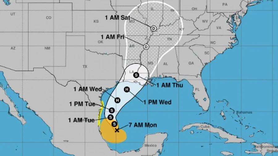
Tropical Storm Francine, which formed Monday in the Gulf of Mexico, is forecast to hit Texas and Louisiana by late Wednesday prompting Texas to activate its emergency response system.
Francine is forecast to reach hurricane strength by Wednesday afternoon, according to the National Hurricane Center (NHC). The storm is not expected to become a “major”—Category 3 or greater—hurricane.
Texas Gov. Greg Abbott put state emergency responders on increased readiness.
“Texas will continue to closely monitor weather conditions to protect the well-being of Texans,” Abbott said in a statement, warning that the system will “bring potential flash flooding threats and heavy rain.”
The governor added that residents “are urged to take the necessary precautions for potential tropical weather, including remaining weather aware, monitoring road conditions, and having an emergency plan to ensure the safety of themselves and their loved ones.”
It’s not clear if Louisiana’s governor will implement similar measures such as declaring a state of emergency. As of Monday morning, no emergency or disaster declaration has been issued.
A hurricane watch has been issued from Cameron eastward to Grand Isle in Louisiana, while a tropical storm watch was also issued from High Island, Texas, to Cameron, Louisiana, and from Grand Isle, Louisiana, to the Mouth of the Pearl River including Lake Pontchartrain and Lake Maurepas, the NHC said.
The NHC said on Monday morning that “life-threatening storm surge and hurricane-force winds” are expected along the coasts of Louisiana and eastern Texas by mid-week, according to a bulletin. A tropical storm watch is in effect for northern Mexico and southern Texas, from the mouth of the Rio Grande to Port Mansfield, Texas.
“The disturbance is expected to become a tropical storm later today, with more significant intensification forecast to occur on Tuesday and Wednesday,” an NHC bulletin said. “The system is forecast to become a hurricane before it reaches the northwestern U.S. Gulf Coast.”
Francine is expected to make landfall in south-central Louisiana, likely as a hurricane by Wednesday at 7 p.m. ET, according to the NHC’s forecasting model. The agency predicts it will be downgraded into a tropical storm by early Thursday morning.
“While it is too soon to pinpoint the exact location and magnitude of impacts, the potential for life-threatening storm surge and damaging winds are increasing for portions of the Louisiana and upper Texas coastlines beginning Tuesday night,” the NHC has said.
The storm system is expected to produce four to eight inches of rain, with localized amounts of 12 inches, from northeastern Mexico northward along parts of the southern Texas coast, and across southern Louisiana and southern Mississippi into Thursday, according to the bulletin.
The heavy rainfall is likely to increase the risk of flash and urban flooding in those states, forecasters warn.
The Atlantic hurricane season, which lasts from June 1 until Nov. 30, tends to peak in early September. The 2024 season so far has been relatively quiet, researchers say.
There have been no named tropical storms or hurricanes since mid-August when Hurricane Ernesto was named.
Data from Colorado State University scientists show that approximately 68 percent of all tropical activity in the Atlantic Basin occurs after Sept. 1.
Earlier this year, the National Oceanic and Atmospheric Administration (NOAA) predicted that the 2024 season would have 17 to 24 named storms, with eight to 13 becoming hurricanes. Of that figure, between four and seven would be major hurricanes, the agency said.
Forecasters with the NHC are also monitoring two other disturbances, both emerging in the eastern and central tropical Atlantic. One area of low pressure has a 60 percent chance of forming into a tropical depression within the next 48 hours “while the system meanders over the central tropical Atlantic,” said the agency.
A second area of low pressure, to the east of the first, has a 60 percent of becoming a depression within the coming seven days, the NHC added.
From The Epoch Times

