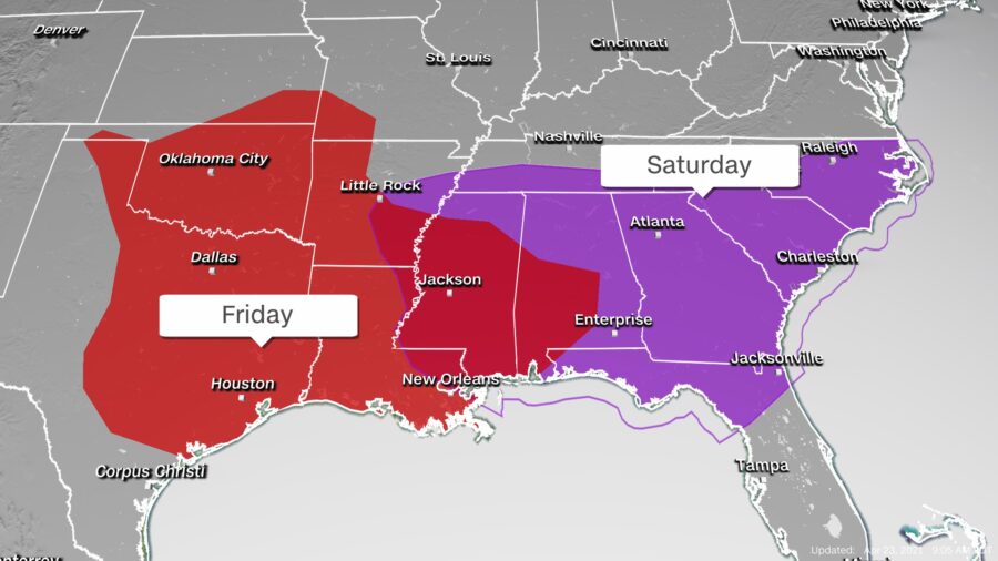
The threat of severe storms is forecast for the Southeast on Saturday, bringing the potential for large hail, damaging winds, and even a few tornadoes.
Severe storms struck the central and southern United States on Friday spawning at least one confirmed tornado in Texas and several reports of baseball-sized hail or larger.
This same storm system will track east bringing similar hazards to more than 30 million people across the Southeast on Saturday.
An enhanced risk of severe weather, level three out of five, has been issued by the National Weather Service’s Storm Prediction Center. The area under enhanced risk stretches across portions of Alabama, Georgia, and Florida. It includes the cities of Mobile and Montgomery in Alabama, Columbus and Savannah in Georgia, and Tallahassee, Florida.
A ‘slight’ risk, level two out of five, encompasses the enhanced risk and includes Atlanta, Jacksonville, Birmingham, and Columbia, South Carolina.
“Widely scattered to scattered severe thunderstorms are expected on Saturday across parts of the Southeast. All severe hazards appear possible including large to very large hail, damaging wind, and tornadoes,” according to the storm center.
The first round of severe storms is expected Saturday morning, as a strong line of thunderstorms tracks across the South, affecting Louisiana, Mississippi, and Alabama. The main threat along this line of storms will be damaging winds, but some short-lived, embedded tornadoes are possible.
Tornado watches were issued early Saturday morning for portions of southern Mississippi, southern Alabama, southern Georgia, and the Florida Panhandle.

The first round of storms will track across the Gulf Coast through the early afternoon. A second round of storms is forecast to bring more rain and severe hazards to some of the same areas affected in the morning.
The greatest threat for tornadoes will be in the afternoon and evening hours across portions of southeast Alabama, southwest Georgia, and northern Florida.
Much of Alabama, southwest Georgia, and the Florida Panhandle could see hail the size of golf balls or larger Saturday afternoon.
By the evening hours, the second round will affect Georgia and the Carolinas before pushing offshore early Sunday morning.
Since this severe threat continues throughout the overnight hours, it is important for residents in these areas to have weather alerts set up on their cellphones to awaken them in case any bad weather immediately threatens your town.
Flash Flood Threat
Along with the severe weather, there is the risk for flash flooding especially across portions of Alabama, Georgia, Florida, and South Carolina.
A ‘slight’ risk, level two out of four, of excessive rain has been issued by the weather service’s Weather Prediction Center for this region.
There is an “elevated flood threat for creeks and smaller streams, especially where storms may track over the same areas,” the weather service office in Atlanta said (pdf).
These storms are forecast to produce a widespread rainfall of between 2 and 4 inches across the Southeast on Saturday. Even higher rainfall amounts of 4–6 inches are forecast across southern Alabama, southern Georgia, and northern Florida today.
Severe weather in the United States should settle down Sunday and Monday, but the Storm Prediction Center suggests a return on Tuesday for parts of the southern Plains: “Confidence remains high that severe thunderstorms will impact the central and southern Plains on Tuesday. [Forecast variables] continue to suggest the potential for supercells capable of all severe hazards.”

