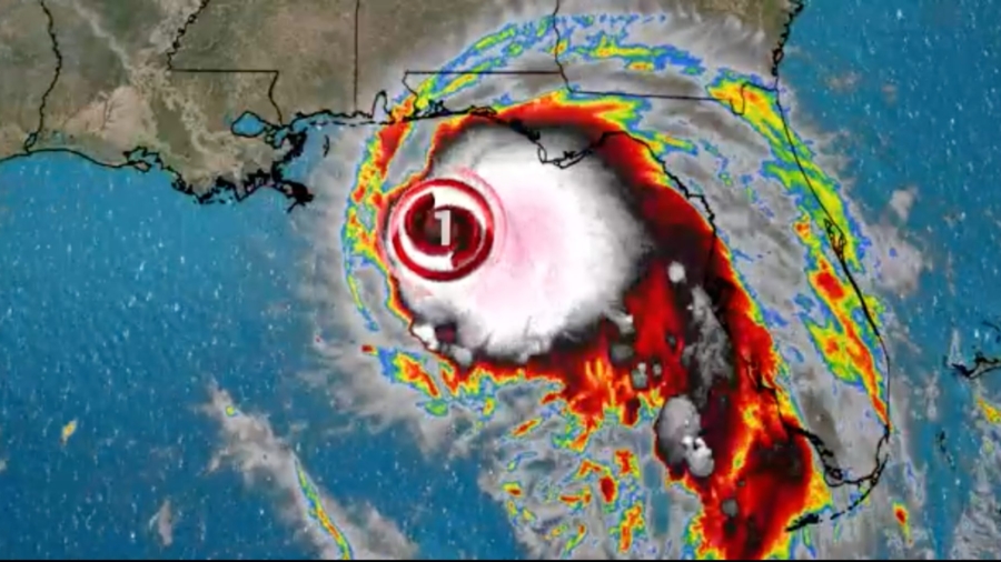
Hurricane Sally formed Monday morning and appeared to shift east, placing Mississippi’s and Alabama’s entire coasts under a hurricane warning while veering away from Louisiana, where the southwest coast is still recovering from Hurricane Laura.
Sally is threatening to make landfall Tuesday as a Category 2 storm. Data from a hurricane hunter aircraft shows the wind speeds strengthening, and the storm could hit the coast with 105 mph winds, just a few miles per hour shy of a Category 3 designation, the National Hurricane Center says.
The latest update, released at midday by the National Hurricane Center, showed the storm about 165 miles southeast of Biloxi, Mississippi.
The storm presently has 90 mph winds, but of more concern is its sluggish final approach, forecasters say.
“Since Sally is forecast to be moving very slowly around the time of landfall, a slower rate of weakening is indicated since a large portion of the circulation will remain over water for some time,” the weather service said.
Mississippi Gov. Tate Reeves signed a preliminary state of emergency Sunday. Mississippi officials are working to make decisions on possible mandatory evacuations, he said Sunday.
Alabama and Mississippi Get Ready
Officials were handing out sandbags in Saraland, Alabama, north of Mobile, while residents on Dauphin Island, a barrier isle on the Alabama coast, were also preparing for flooding, CNN affiliate WALA reported.
“We’re lucky enough to live in the center of the island, so it’s not hopefully gonna be too bad for us,” Ryan Gieselman told the station. “I hope it really just misses us and we can go on with the rest of our summer and enjoy it, but if it hits us, just be prepared and be ready to hunker down.”
Gov. Kay Ivey issued a state of emergency for Alabama, saying, “Bad weather is nothing to take lightly. … As your governor, you have my assurance that every resource will be available if we need it. Be safe, Alabama.”
Coastal areas between eastern Louisiana and western Florida could see anywhere between 1 and 8 feet of storm surge, though the coast between the Mississippi River and Ocean Springs, Mississippi, east of Biloxi, could witness up to 11 feet, the National Hurricane Center forecast.
In Gulfport, Mississippi, hardware and grocery stories are stocked, but at least one store manager said he isn’t seeing the normal crush of customers stocking up on plywood and other wares, according to CNN affiliate WLOX.
“I think a lot of the folks were still stocked up when Marco and Laura come up because it was a near miss, but a lot of folks got prepared for that,” said Bill Collins, who manages a hardware store in Gulfport.
Resident Al Ward was grabbing propane tanks in case he needs to do his cooking outdoors once the storm passes, he said.
“I’m doing what everybody else that has any sense would do,” Ward told the station. “I’m being prepared for the worst and hoping it will be as it has been earlier this year. We dodged the bullet.”
Louisiana Not Taking Chances
Though Louisiana is no longer expected to face a direct hit, “an extremely dangerous and life-threatening storm surge is expected” in the southeast portion of the state, especially from Port Fourchon eastward, the hurricane center warned.
Gov. John Bel Edwards declared a state of emergency, and mandatory evacuations have been issued for part or all of several parishes, and for New Orleans residents who live outside the levee protection system. Most residents live inside the protection system.
At least one nursing home has started evacuating residents, Edwards said. Three jails have also evacuated 1,200 inmates, he said.
Venetian Isles, Lake Catherine and Irish Bayou, which are not protected by substantial levees, could see storm surge of up to 11 feet, NOLA Ready, the city’s emergency preparedness network, said in a tweet.
New Orleans’ 99 drainage pumps, critical to staving off street flooding, are fully operational, according to the city’s Sewerage and Water Board, which activated its emergency operations center early Monday. The city has also signed an emergency declaration and is distributing sandbags.
“You should be gathering your emergency supplies, three days’ worth,” Collin Arnold, director of the New Orleans Office of Homeland Security and Emergency Preparedness, warned.
Officials “have every reason to believe that this storm represents a very significant threat to the people of Southeast Louisiana,” Edwards said, adding he has spoken to President Donald Trump and is submitting a pre-landfall federal declaration request.
The Federal Emergency Management Agency has approved assistance for 21 parishes impacted by Laura, according to a news release issued Sunday by the governor’s office.
“The bottom line continues to be that Sally is expected to be a dangerous slow-moving hurricane near the coast of southeastern Louisiana, Mississippi and Alabama during the next 2-3 days,” the National Hurricane Center warned.
Sally comes less than three weeks after Hurricane Laura made landfall as a Category 4, causing widespread flooding and damage in southwest Louisiana and leaving six people dead.
It carried the same force as a storm from more than 150 years ago, the strongest to ever strike the state. Laura also destroyed power grids, and repairs are anticipated to take weeks, if not months, officials said.
Almost 80,000 homes remain without power in southwest Louisiana as of Monday morning. At Laura’s peak, more than 800,000 customers lost electricity.

