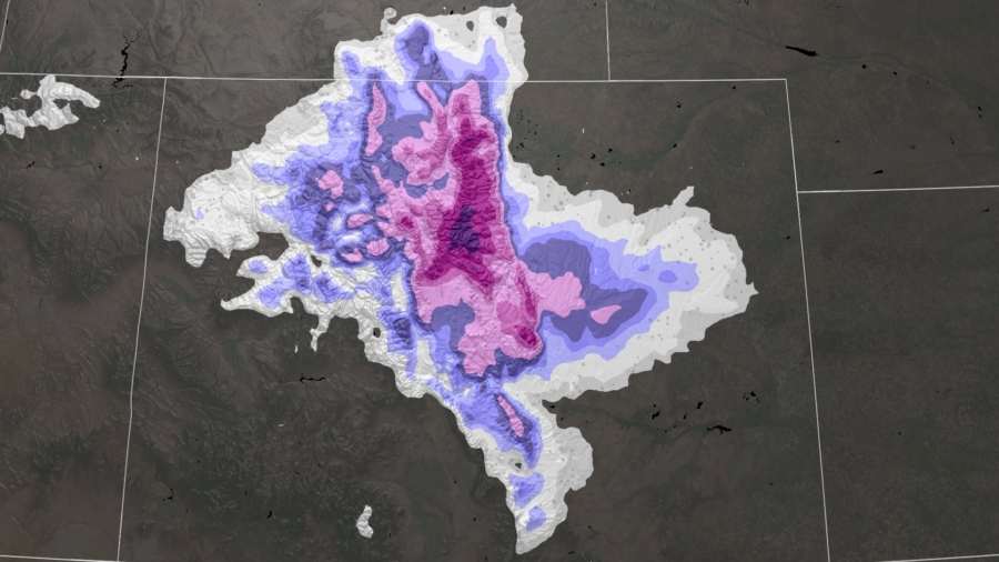
In less than 24 hours, Denver could go from having 90-degree weather to a potentially historic and dangerous snowstorm.
Snowfall amounts could be as high as two to three feet in the higher elevations, and up to eight inches in the city of Denver, according to the National Weather Service (NWS) office in Boulder.
“It’s going to be quite the change over the next 24 hours, so people traveling up into the higher elevations—especially Friday afternoon and evening—really need to be prepared for those changing conditions,” said NWS Boulder Meteorologist Zach Hiris. “Anytime there’s really heavy snow like that, it can cause tremendous impacts to Interstate 70, or some of the lesser traveled highways into our higher elevations.”
Friday afternoon through Saturday morning “travel may become very difficult to impossible due to heavy snowfall on roadways,” NWS Boulder said.
Some of the lower elevations, including Denver, could potentially set records.
The forecast right now is for Denver to receive 4 to 8 inches of snow between Friday and Saturday. In Denver, the daily snowfall record for May 20 is 3.0 inches of snow and May 21 is 3.8 inches. Depending on when the snow falls, these daily records could be broken.
“This is certainly going to be an impactful storm, even if there aren’t any records,” said NWS Boulder meteorologist Zach Hiris.
The mile-high city is under a winter storm warning through noon local time on Saturday but the heaviest snowfall is expected to blanket the city Friday afternoon through the evening hours.
“Heavy snow will accumulate on tree branches and powerlines, possibly causing them to break and lead to power outages,” NWS Boulder said in their winter storm warning.
The last few weeks have been unseasonably warm in Denver, leading to a lot of new tree growth, which won’t be able to hold up to even a few inches of heavy, wet snow.
Up in Denver’s foothills, even more snow is forecast, which means the storm’s impact could be more widespread.
“In the foothills, where we’ve got one to two feet of snow in the forecast, there could be some pretty significant tree damage. Also, power outages—whether that’s from trees falling on the power lines or just the power infrastructure itself not being able to handle the snow load,” said Hiris. He added, “That’s really a big concern for us—not only for the Denver Metro, but for most of our foothills.”
Avalanches could also be a concern, as new snow falls on partially melted snow from the recent warm weather in the Colorado mountains.
This late-season snow storm will be accompanied by a surge of bitterly cold air. Temperatures will plummet from a high temperature of 88 degrees on Thursday to highs barely getting into the 40s by Saturday.
Record morning low temperatures are also possible Saturday and Sunday morning, with temperatures forecast to be in the upper 20s.
A freeze warning is also in effect for the region as “unseasonably cold temperatures Saturday morning may kill sensitive vegetation or unprotected outdoor plumbing,” according the the NWS Boulder office.

